|
-- Jennie Miller, PhD ‘15 One of the biggest challenges for a wild carnivore today is avoiding conflict with humans. With livestock now using 30% of ice-free land on our planet, most carnivores likely live within or adjacent to a buffet of domestic animals, served up fear-free, tender and ready for the taking. But this livestock buffet has hidden costs when owners use lethal control or poison carcasses to kill carnivores and reduce future livestock losses. Livestock owners and wildlife managers have struggled for centuries to protect domestic animals and carnivores alike by implementing a variety of nonlethal tools to reduce attacks, but knowing when and where to focus tools is tricky. Last week Biodiversity and Conservation published my review on an emerging method for mapping livestock depredation hotspots, which aims to strengthen efforts to reduce human-carnivore conflict. The article describes spatial risk models how they have been used by conservationists in outreach with livestock owners, managers and policymakers. For instance, in rural Tanzania, the Ruaha Carnivore Project shared risk maps with livestock owners through PowerPoint presentations conveyed in Swahili and delivered during educational movie nights to help people recognize distributions of predator risk in their area. In Gujarat, India, risk maps on Asiatic lion attacks on livestock were included in conflict management manuals distributed to high-risk villages. In Hunchun, China, hotspot maps were included in a policy document that reportedly contributed to the government agency increasing efforts to resolve human–tiger conflict. In other words, maps are an ideal tool for communicating information with non-scientist audiences. And with increasing access to the internet and smartphone technology across the world, risk maps can be shared with stakeholders in innovative ways. A great example is the interactive online map of wolf risk to livestock in Wisconsin, created by the Carnivore Coexistence Lab at the University of Madison-Wisconsin, where ranchers can type in their address and view to risk over several years around their property. Below are a few samples of the variety of visual forms that risk maps can take.  A sample of livestock depredation risk hotspot maps for (a) grizzly bears in Montana, (b) lions in Gujarat, India, (c) tigers in India and (d) pumas in Argentina. Figure from Miller 2015. Especially if information already exists on the when and where of livestock kills, models can be relatively simple and inexpensive to integrate into the conservation decision-making process. In areas where financial compensation programs already exist, management agencies or non-profit organizations often have large databases of livestock depredation cases that can be used to model carnivore risk to livestock. The process of building and applying risk maps can roughly follow the steps outlined below: 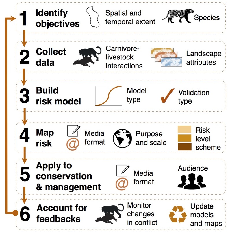 Steps for creating and applying predation risk maps to mitigate human–carnivore conflict. Figure from Miller 2015. My PhD involved developing spatial risk models for tigers and leopards on livestock in Kanha Tiger Reserve, central India. I saw first-hand how intuitively managers could understand risk maps and how maps could help inform management actions (e.g. fencing out livestock in high-risk areas).
Based on my experience of how easy and inexpensive risk models and hotspot maps are to build and use, I encourage researchers and managers to explore the many applications of these maps for their work. In particular, future efforts should focus on: · Building and validating robust models across more areas of the world where carnivore attacks on livestock cause major problems for local livelihoods and carnivore conservation. · Integrating risk models into long-term management and monitoring to explore whether they can effectively reduce human-carnivore conflict. · Developing new and innovative methods for displaying, sharing and applying results from risk models to reach new audiences (e.g. citizen science and smartphone apps). · Greater outreach with policymakers so that risk maps can inform large-scale decisions on conflict. · Investigating ecological and behavioral feedbacks that may occur after livestock grazing or patterns protection efforts change (would make a fantastic PhD project!). Spatial risk models and hotspot maps offer a simple, quantitative and insightful tool for the conservation toolkit. With greater and more widespread usage, risk models and maps will continue to improve the effectiveness of mitigation efforts for reducing livelihood losses and strengthening carnivore conservation worldwide. For more information, read the article: Miller JRB. 2015. Mapping attack hotspots to mitigate human-carnivore conflict: approaches and applications of spatial predation risk modeling. Biodiversity and Conservation (early online). PDF available here.
39 Comments
Margaret
10/31/2015 11:07:02 am
I really liked this post, Jennie! As one who is concerned about both wildlife survival and, of course, our farmer friends' economic viability, anything that helps reduce "human–carnivore conflict" is a great thing in my eye. 2/21/2023 01:29:59 pm
Thanks for another wonderful post. Where else could anybody get that type of info in such an ideal way of writing? 10/8/2023 03:05:35 am
good information and best at all its so useful for me thanks 10/8/2023 06:00:54 am
Asia Panel is one of the top manufacturers of wall and ceiling sandwich panels. 11/15/2023 04:30:52 am
good thanks about article
Electric smoke vapes Products have become a significant trend among both smokers looking to quit and individuals who have never smoked traditional cigarettes. The market continues to evolve, with new devices and flavors constantly emerging. One of the key attractions of electric smoke vapes is the wide range of flavors available. Users can choose from traditional tobacco, menthol, fruit, dessert, and many other flavors.
https://77jlslot.com/category/jili-slot-game 5/6/2024 01:35:28 pm
Cashback is like a friendly pat on the back after a bet. 카림 (Karim) knows how to keep players happy, combining fair play with that extra incentive. 5/22/2024 02:55:06 am
Slope Game's difficulty creates attractive challenges for players. 6/3/2024 11:37:09 am
I want you to thank for your time of this wonderful read!!! I definitely enjoy every little bit of it and I have you bookmarked to check out new stuff of your blog a must read blog 6/5/2024 07:54:11 pm
I’m excited to uncover this page. I need to to thank you for ones time for this particularly fantastic read !! I definitely really liked every part of it and i also have you saved to fav to look at new information in your site. 6/7/2024 06:03:26 pm
I wanted to leave a little comment to support you and wish you a good continuation. Wishing you the best of luck for all your blogging efforts. 6/14/2024 04:51:00 am
Thank you for the information , visit Banyuwangi tourism at. <a href="https://amanahtrans.my.id/">Sewa mobil banyuwangi</a> 6/16/2024 08:31:45 am
This is a good article. I am inclined to write comments here to show my support that it is about time that we need to preseve the space for animals to live. We can not live in the world just by ourself, because our world is co exist independence. It is about time we do something for that. 6/24/2024 10:16:30 am
Based on my experience of how easy and inexpensive risk models and hotspot maps are to build and use, I encourage researchers and managers to explore the many applications of these maps for their work. In particular, future efforts should focus on:
sara
7/13/2024 03:05:37 am
really helpfull 7/25/2024 04:30:28 am
Awesome and interesting article. Great things you've always shared with us. Thanks. Just continue composing this kind of post. Leave a Reply. |
Archives
November 2019
Categories
All
|
 RSS Feed
