|
--Kevin McLean, PhD Candidate I looked at my calendar this morning and realized that it has now been over 7 weeks since I returned from my field season in Panama. Seeing as I was only gone for 12 weeks, I suppose it is about time that I stop telling people I am still “adjusting to being back.” With that out of the way, on to the fieldwork update! I departed for Panama in mid-December to finish up the necessary training and do a bit of testing and tinkering for my dissertation research. A portion of my project will involve monitoring arboreal (tree-dwelling) mammals in the rainforest canopy using motion-sensitive cameras, or “camera traps.” While I’ve spent a fair amount of time learning how to use camera traps on the ground, setting them up 6-10 stories above the forest floor was a whole new challenge. First on the agenda was learning how to actually get into the trees. I spent three weeks at the Institute for Tropical Ecology and Conservation (ITEC) taking a tree climbing course, which I sometimes refer to as “Canopy Access Techniques for Research” to sound unbelievably fancy. While three weeks may sound excessive, one of the many goals I set for myself while working on my dissertation was to not die, and my instructor Joe Maher played integral role in giving me the training necessary to succeed in that regard. The next step was figuring out how to mount the cameras in the trees. I had a fair amount of help with this from Dr. Tremaine Gregory, who was kind enough to share the designs she used for her work in Peru. I put together a set of six mounts using a couple different designs that allowed me to monitor animals on pretty much any branch size or angle. Once I got some initial troubleshooting out of the way, I was able to get some pretty great photos of the arboreal wildlife in Bocas del Toro. Some of the species that crossed the cameras included capuchin monkeys, green iguanas, woolly opossums, and climbing rats. After about a month in Bocas I traveled to the Canal Zone to set up my cameras in the forests in the Barro Colorado Island Nature Monument. Dr. Stefan Schnitzer, the primary investigator for the Liana Ecology Project was kind enough to allow me to set up cameras on his research plots on the Gigante Peninsula. 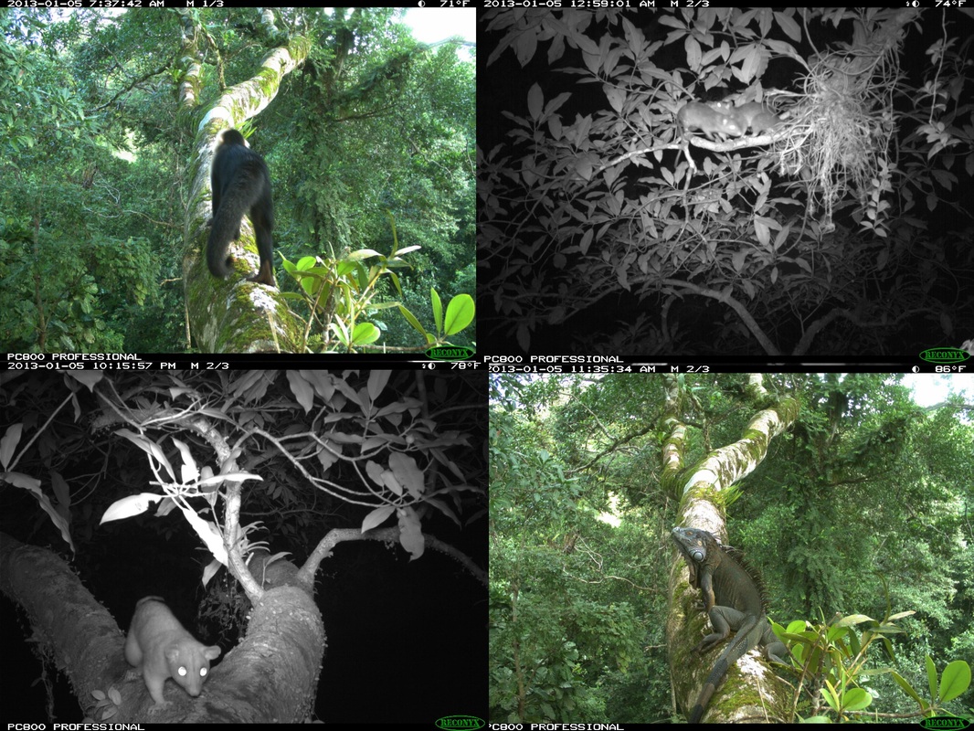 Clockwise from upper left: capuchin monkey, climbing rats, green iguana, woolly opossum. I chose two trees on Gigante peninsula, one in a plot in which all the lianas had been removed, and another in a control plot. Once again it took a bit of fiddling to get things running smoothly, but after a several solid weeks I managed to get photos of more capuchins and woolly opossums, as well as some coatimundis, kinkajous, squirrels, and toucans. I thankfully made it back to New Haven in one piece, where I will spend my time going through photos and working on the other pieces of my dissertation until I return to Panama January 2014. 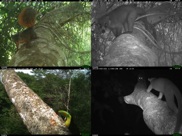 Clockwise from upper left: squirrel, coatimundi, kinkajous, toucan.
15 Comments
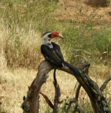 Why do species occur where they do? How do we accurately predict their occurrence? These questions have inspired naturalists and scientists for many years. Accurate species occurrence information can be used to select protected areas, identify movement corridors, and develop successful management practices. The research I conduct at Mpala Research Centre in Laikipia, Kenya investigates how environmental conditions and spatial scale influence species occurrence patterns. Both humans and animals are known to select resources at different spatial scales. For example, when choosing a city in which to live, I might consider weather patterns, local amenities, and job availability. When purchasing a home, I would want to know a house’s square footage, yard size, and safety. Animals respond to environmental conditions at different scales in similar ways. When selecting a home range, a bird might prioritize food resources, water availability, and nearby competitors. When selecting a nest site within a home range, ease of entry and shelter from predators may be more important. These habitat selection processes, combined across many individuals, determine a species’ local distribution. The first step in studying scale-dependent occurrence patterns is to measure the scales where habitat selection takes place. One method uses movements made by individuals over long time periods. Places where animals move short distances and turn in many directions likely contain important resources like food; places where animals move long distances over short time periods might be dangerous or contain less food or water. Recent technological developments make it possible for very small GPS tags (less than 20 grams) to collect a precise GPS location every 20 minutes, and run for months on solar-powered batteries. During August – October 2012, my team attached GPS tags (built by the University of Konstanz, Germany) to six adult Von der Decken’s hornbills at Mpala. One tagged hornbill often flies by the research station and dining area, showing off his GPS “backpack.” 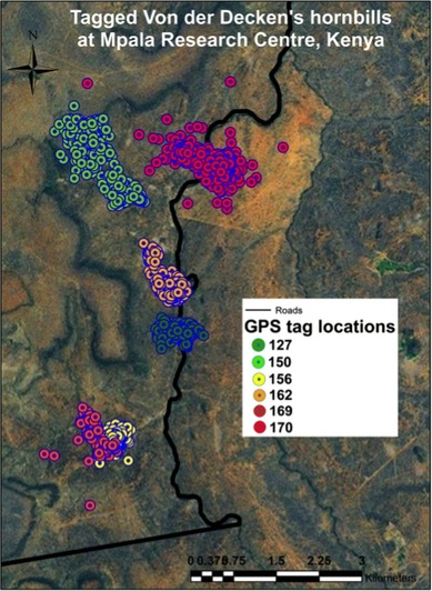 Movement data are collected by placing weatherproofed antennas, receivers, and memory units near where tagged birds roost at night (search www.movebank.org to see where tagged birds spend their time at Mpala Research Centre). After several months, we will collect enough movement data to identify important spatial scales for von Der Decken’s hornbills. Once these critical features are measured, we will build models that incorporate data on environmental conditions to understand how hornbills select habitat and resources across spatial scales. Measuring the scales that are important to different species will also help us understand how species coexist by splitting environmental resources. Together, a fuller understanding of scale dynamics and the detailed information collected by GPS tags will move us closer to understanding and predicting species occurrence patterns.
|
Archives
November 2019
Categories
All
|
 RSS Feed
