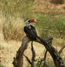
 Why do species occur where they do? How do we accurately predict their occurrence? These questions have inspired naturalists and scientists for many years. Accurate species occurrence information can be used to select protected areas, identify movement corridors, and develop successful management practices. The research I conduct at Mpala Research Centre in Laikipia, Kenya investigates how environmental conditions and spatial scale influence species occurrence patterns. Both humans and animals are known to select resources at different spatial scales. For example, when choosing a city in which to live, I might consider weather patterns, local amenities, and job availability. When purchasing a home, I would want to know a house’s square footage, yard size, and safety. Animals respond to environmental conditions at different scales in similar ways. When selecting a home range, a bird might prioritize food resources, water availability, and nearby competitors. When selecting a nest site within a home range, ease of entry and shelter from predators may be more important. These habitat selection processes, combined across many individuals, determine a species’ local distribution. The first step in studying scale-dependent occurrence patterns is to measure the scales where habitat selection takes place. One method uses movements made by individuals over long time periods. Places where animals move short distances and turn in many directions likely contain important resources like food; places where animals move long distances over short time periods might be dangerous or contain less food or water. Recent technological developments make it possible for very small GPS tags (less than 20 grams) to collect a precise GPS location every 20 minutes, and run for months on solar-powered batteries. During August – October 2012, my team attached GPS tags (built by the University of Konstanz, Germany) to six adult Von der Decken’s hornbills at Mpala. One tagged hornbill often flies by the research station and dining area, showing off his GPS “backpack.” 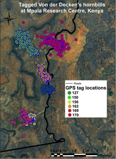 Movement data are collected by placing weatherproofed antennas, receivers, and memory units near where tagged birds roost at night (search www.movebank.org to see where tagged birds spend their time at Mpala Research Centre). After several months, we will collect enough movement data to identify important spatial scales for von Der Decken’s hornbills. Once these critical features are measured, we will build models that incorporate data on environmental conditions to understand how hornbills select habitat and resources across spatial scales. Measuring the scales that are important to different species will also help us understand how species coexist by splitting environmental resources. Together, a fuller understanding of scale dynamics and the detailed information collected by GPS tags will move us closer to understanding and predicting species occurrence patterns.
30 Comments
10/18/2016 12:58:19 am
Really your post is too wonderful, carry on your work and sharing your information with us.
loom solar
3/19/2021 07:42:02 am
You can become a Solar <a href="https://www.loomsolar.com/collections/dealers-distributor-business-opportunities-in-india" target="_blank">distributor</a> and help in sustaining the future energy by investing the Green energy.Did you know that Solar Energy today is cheaper than Grid energy electricity? Or that the cost of energy from an Invertor or Diesel Generator is about 2~3 times more than the grid energy that is used to charge the batteries? Depending upon your consumer category and location, you could reduce your monthly bill by up to 40%, sometimes even more.
loom solar
3/19/2021 07:43:11 am
https://www.loomsolar.com/collections/dealers-distributor-business-opportunities-in-india 11/25/2022 10:01:47 am
You try to submit more links than the industrial shredder. 12/27/2022 02:33:07 am
Enjoyed reading the article above, really explains everything in detail, the article is very interesting and effective. Thank you and good luck… This site is very helpful for me. I love that site and it is also an informative site This can include measurements of vegetation, water availability, and temperature at different scales, ranging from meters to kilometers. These environmental variables can be measured using ground-based sensors or remote sensing techniques like satellite imagery or aerial photography. Thank you 7/12/2023 09:08:11 pm
Together, a fuller understanding of scale dynamics and the detailed information collected by GPS tags will move us closer to understanding and predicting species occurrence patterns. Cheers 2/12/2024 03:29:10 pm
The collection of movement data for von Der Decken's hornbills involves the deployment of weatherproofed antennas, receivers, and memory units in areas where tagged birds roost at night. This data collection process allows researchers to track the birds' movements over several months, ultimately identifying important spatial scales for their habitat selection.
<a href="https://128.199.219.201/">kapuas88</a> Situs Judi Online Terpercaya dan Berlisensi Resmi. Leave a Reply. |
Archives
November 2019
Categories
All
|
 RSS Feed
